100% free!


Time and longitude Difference between UTC and Pacific Standard Time PST is 7h during summer At noon PST UTC time is ?

Control > aircraft

exemple 24
9h utc, 5h utc,4h utc,2h utc.

Indicate how an eastbound direction in air navigation is represented ?

exemple 25
Indicate how an eastbound direction in air navigation represented

Indicate how a westbound direction in air navigation is represented ?

exemple 26
Indicate how a westbound direction in air navigation represented 27 °, 9 °,8 °, 36 °.

  • exemple 27
    Indicate airspace s where a pilot can use a small remotely piloted aircraft in basic operations All uncontrolled airspace, all controlled airspace, class a airspace, class c d airspace.

  • exemple 28
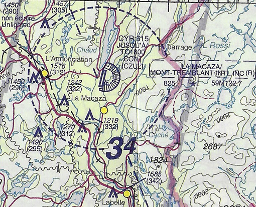
    What does acronym 'vnc' stands Vfr navigation charts, vfr terminal area charts, visual navigation chart, vfr controlled navigation path.

  • exemple 29
    What does acronym 'vta' stands Vfr terminal area charts, vfr navigation charts, vertical terrain arrival, verticale terrain avoidance.

  • exemple 30
    Identify statement that correct very high frequency vhf waves They follow a straight trajectory can only be captured in line of sight, they follow relief of earth, they are affected magnetic fields, they spread a short distance only.

  • Question Section 5: Navigation 24 Answer 8

    Which of following statements correct The meridians are half circles connecting true poles, the meridians are parallel to equator, the parallels are numbered from to 36 ° from greenwich, the meridians are numbered from to 3° from greenwich.

  • Question Section 5: Navigation 24 Answer 9

    Utc the local mean time For prime meridian, for international date line (idl), at equator, at north pole.

  • Question Section 5: Navigation 24 Answer 10

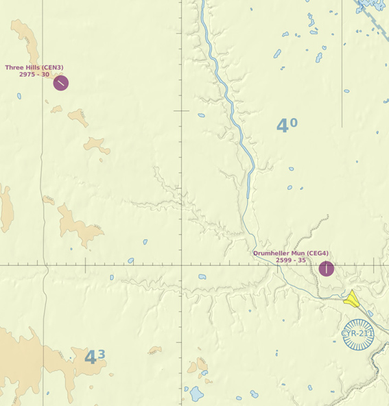
    The direction and distance between drumheller aerodrome and three hills aerodrome are 48 Northwest, 2nm, soutwest, 2nm, soutwest, 2 nm, northwest, 2 nm.

  • Question Section 5: Navigation 24 Answer 11

    Latitude and longitude are respectively measured an angular deviation of ° to 9 ° n or s from° to8 ° e or w,° to 9 ° n or s from° to 36 ° e or w,° to8 ° e or w from° to 9 ° n or s,° to 36 ° e or w from° to 9 ° n or s.

  • Question Section 5: Navigation 24 Answer 12

    The coordinates of intersection point between equator and greenwich meridian are °n°e/w, 9 °n°w, 9 °n°e, °n9 °e.

  • Question Section 5: Navigation 24 Answer 13

    The geographical coordinates of a place are given reference At equator the prime meridian, the prime meridian the longitude of aera, the prime meridian the latitude of aera, at equator the local meridian.

  • Question Section 5: Navigation 24 Answer 14

    The waves emitted low medium and high frequency stations are of two types Surface waves space waves, terrestrial waves stellar waves, orographic waves space waves, vhf waves uhf waves.

  • Question Section 5: Navigation 24 Answer 15

    Whenever possible notification of conditions requiring issue of a notam will be distributed in advance Five hours, ten hours, one day, twelve hours.


Exclusive rights reserved. Reproduction prohibited under penalty of prosecution.

344 Free Training Exam Other source study: Codebateau examen 24